The help section provides two documents designed to help users with the tool.
The first document (User Manual) describes the tool’s major functionalities and provides detailed explanations of each page and screen.
The second document (Technical Manual) provides in-depth explanation of the theoretical background of the Tool.
Additional information is available to the users for all major functions of the tool by hovering the mouse pointer over the help icon ( ).
).
Tool functions are accessible through the Map interface or by selecting the menu options.
Research and Development Team
Slobodan P. Simonovic, Professor Emeritus, Western University
Andre Schardong, Post Doctoral Fellow, Western University
Dan Sandink, Institute for Catastrophic Loss Reduction
Partners
Institute for Catastrophic Loss Reduction
This software is provided "as is", without warranty of any kind, express or implied, including but not limited to the warranties of merchantability, fitness for a particular purpose and non infringement.
In no event shall the authors or copyright holders be liable for any claim, damages or other liability, whether in an action of contract, tort or otherwise, arising from, out of or in connection with
the software or the use or other dealings in the software.
This website/tool requires the use of browsers with Javascript and jQuery compatibility. The latest versions of Chrome, Firefox and Internet Explorer were tested and compatible.
The data and stations from Environment Canada used in this tool are freely available from the Environment Canada website: http://climate.weather.gc.ca/prods_servs/engineering_e.html
Global Climate Model data are downloaded and obtained from http://cmip-pcmdi.llnl.gov
The information provided should be used at your own risk. By using this Tool you agree with these terms.
Please check the Help section for more information.
Third party software used to build the tool:
- jQuery and jQuery UI: jQuery is a fast, small, and feature-rich JavaScript library. (http://jquery.com/)
- Handsontable: A minimalistic Excel-like data grid editor for HTML, JavaScript & jQuery. (http://handsontable.com/)
- Google™ Maps: Google Maps information and photographic imagery are used under license by Google. The map information and photographic imagery contain trade names, trademarks, service marks, logos, domain names, and other distinctive brand features. (http://maps.google.com/)
- Highcharts™: Highcharts is a charting library written in pure JavaScript, offering an easy way of adding interactive charts to your web site or web application. Highcharts currently supports line, spline, area, areaspline, column, bar, pie, scatter, angular gauges, arearange, areasplinerange, columnrange, bubble, box plot, error bars, funnel, waterfall and polar chart types. (http://highcharts.com/)
Research and Development Team
Slobodan P. Simonovic, Professor Emeritus, Western University
Andre Schardong, Post Doctoral Fellow, Western University
Dan Sandink, Institute for Catastrophic Loss Reduction
Partners
Institute for Catastrophic Loss Reduction (www.iclr.org/)
Included in this section is a list of the most frequently asked questions by users during the IDFCC tool development process. If your question is not addressed in the list below, please do not hesitate to email us with your question.
-
Q: What are SSPs?
A: CMIP5 used Representative Concentration Pathways (RCPs) to describe different levels of greenhouse gases and other radiative forcings that might occur in the future. Three of these RCPs are used by IDF_CC tool. Parallel modelling is concentrated on how socioeconomic factors may change over the next century. These include changes to population, economic growth, education, urbanization and the rate of technological development. Shared Socioeconomic Pathways (SSPs) consider five different ways in which the world might evolve in the absence of climate policy and how different levels of climate change mitigation could be achieved, when the mitigation targets of RCPs are combined with the SSPs. These two efforts are designed to be complementary. The RCPs set pathways for greenhouse gas concentrations and, effectively, the amount of warming that could occur by the end of the century. The SSPs set the stage on which reductions in emissions will – or will not – be achieved. The users of the IDF_CC tool have both options available for the development of IDF relationships under climate change.
-
Q: What is CMIP6?
A: CMIP6 represents a substantial expansion over CMIP5, in terms of the number of modelling groups participating, the number of future scenarios examined and the number of different experiments conducted. In the lead up to the IPCC Assessment Report 6, the energy modelling community has developed a new set of emissions scenarios driven by different socioeconomic assumptions. These are the named Shared Socioeconomic Pathways (SSPs). A number of these SSP scenarios have been selected to drive climate models for CMIP6. The IDF_CC tool offers to its users an opportunity to use CMIP6 climate models. Thirty models are added to the tool’s database under CMIP6.
-
Q: What are RCPs?
A: The international climate modelling community has adopted four Representative Concentration Pathways (RCPs) through the Intergovernmental Panel on Climate Change (IPCC). The scenarios range from RCP 8.5, which corresponds to a “non-climate policy” scenario translating into high severity climate change impacts, to RCP 2.6, which is a future requiring stringent climate policy to limit greenhouse gas emissions, translating into low severity impacts. Two middle scenarios, RCPs 4.5 and 6.0, were selected by the IPCC to be evenly spaced between RCPs 2.6 and 8.5. For more details please check this document: RCP Table.pdf
-
Q: What is CMIP5?
A: With the success of CMIP3 and feedback from scientists from various backgrounds, the climate modellers in 2008 added several new dimensions to develop the CMIP5 group of GCMs. The IDF_CC tool is using 24 CMIP5 GCMs. The IPCC Fifth Assessment Report is based on the observations derived from the extended set of experimental simulations in the CMIP5 project. CMIP5 proposed four new scenarios (three of which are used by the IDF_CC tool), also known as Representative Concentration Pathways or RCPs, which vary from the previous scenarios in CMIP3. Since then, several studies have considered CMIP5 models in determining the influence of climate changes to flood risk at various spatial scales.
-
Q: What are CMIPs
A: In the quest for propelling climate-related research, the World Climate Research Programme (WCRP) initiated the Coupled Model Intercomparison Project (CMIP) in 1995. With the utilization of advanced climate models, scientists and researchers have gained deeper insights into understanding of the processes and mechanisms that influence the hydro-climatological phenomenon due to climate variability. With their continuous evolution, the climate models, or General Circulation Models (GCMs), have been put to use extensively by the hydrological research community for gaining deeper knowledge on the climate change impacts on flood risk dynamics during historical, present, and future periods. The CMIP climate model experiments serve as inputs into IPCC assessment reports. The CMIP has developed in phases, starting with CMIP 1 in 1995 and 2 in 2000, CMIP3 in 2007, CMIP5 in 2008, and most recently CMIP6 in 2016. For the first time, the CMIP3 working group introduced the concept of ‘emission scenarios’ to depict future climate conditions based on the anticipated demographics, environmental characteristics, and socioeconomic growth. Such scenarios are of particular interest to the decision-makers and policy-makers, as they provide crucial lessons for designing appropriate mitigation and adaptation strategies.
-
Q: How many GCM datasets are available to users?
A: From model outputs available in the CMIP5 and CMIP6 repositories, only models that fulfill the following criteria have been selected for the IDF_CC tool version 5 database: i) daily precipitation in the 1950-2100 range; ii) contain data for 3 RCPs for CMIP5 models (RCP2.6, RCP4.5 and RCP85.) and 4 SSPs for CMIP6 models (SSP1-2.6, SSP2-4.5, SSP3-7.0 and SSP5-8.5), and; iii) all necessary files were successfully downloaded from the corresponding GCM dataset repositories (see UserMan: Section 3.3). Based on the outlined criteria, 24 GCMs from CMIP5 (IPCC AR5) and 30 GCMs from CMIP6 are available in the tool’s database. In addition to the GCMs, 24 bias-corrected GCMs, based on CMIP5 models using the BCCAQv2 method, are included.
-
Q: Why did you exclude RCP 6.0?
A: As an intermediate scenario, results generated using RCP 6.0 are similar to those generated using RCP 4.5. Further, as not all GCMs include runs for RCP 6.0, use of this RCP would limit the number of available GCMs for use in the tool. For intermediate/moderate results please use RCP 4.5.
-
Q: How should I select an RCP, SSP and GCM to generate future IDF curve scenarios?
A: We encourage you experiment with and compare results from multiple combinations of GCMs, the GCM ensemble option and multiple RCPs and SSPs. You can also perform advanced/external analysis using "Export All" on the "IDF under Climate Change" tab. This function allows you to export all IDFs for all GCMs, GCM runs and RCPs.
-
Q: Can I update or edit data for pre-loaded Environment Canada rain stations?
A: You cannot update pre-loaded Environment Canada stations. However, the Tool allows you to create a copy of any station using the "copy station" option. You may then edit data in the copy of the original station.
-
Q: Can I compare future IDF curve scenarios associated with different model runs, RCPs, future time periods and GCMs?
A: Using the "IDF under climate change" functions, you are able to generate IDF curves using data from any of the available GCMs and RCPs. After generating future IDF curves, you can then compare historical IDF curves with those generated using GCM data. You have the option of developing results using one GCM at a time, or developing results based on an ensemble of all available GCMs. Select the "comparison graphs" tab to compare future IDF curves with historical curves, or select the "export all results" to compare results outside of the tool. This option will allow you to compare results from multiple GCM runs, RCPs and multiple GCMs if the ensemble option was selected.
-
Q: How do I export results from multiple GCMs, RCPs, projection periods and GCM runs?
A: You can either copy the results from the tables one by one or use the"export all" feature on the Tool. The export feature will allow you to save all results in a text file. This option is available on the "IDF under Climate Change" tab. The text file will contain IDFs based on historical data and IDFs for future scenarios, including all GCMs, all three RCPs and all GCM runs.
-
Q: Who can view stations that I create in the tool?
A: The stations created by you are not visible to other users. You can share your stations on "Stations and Data" page, selecting the station and providing the email of the person you wish to have access to your Station. The access level for the shared user can be "full access" or "read only". Full access level will allow the user edit or change data.
-
Q: How long do rain station records have to be for use in the tool?
A: A minimum of 10 years of data is required to generate IDF curves.
-
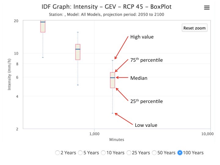
Q: How does the tool communicate uncertainty associated with generating future IDF curves?
A: Users can quickly view the distribution of results produced by each of the 24 raw or 9 bias corrected GCMs datasets available in the tool by selecting the “Box Plot – Uncertainty” tab when generating future IDF curves using the “All Models” GCM option. The illustration provides an example of an uncertainty plot output. The plot was generated for the Toronto City rain station, using the “All Models” GCM option for the period 2050-2100, RCP 4.5. The plot indicates the range of values generated by each of the 18 GCMs for this future scenario. See image illustrating how to read box plots: